NASA Mapping Toa Baja Disasters
Toa Baja Disasters: Mapping Tropical Storm Susceptibility in Puerto Rico’s ‘Underwater City’ Using NASA Earth Observations to Assist the Municipality’s Intervention Efforts
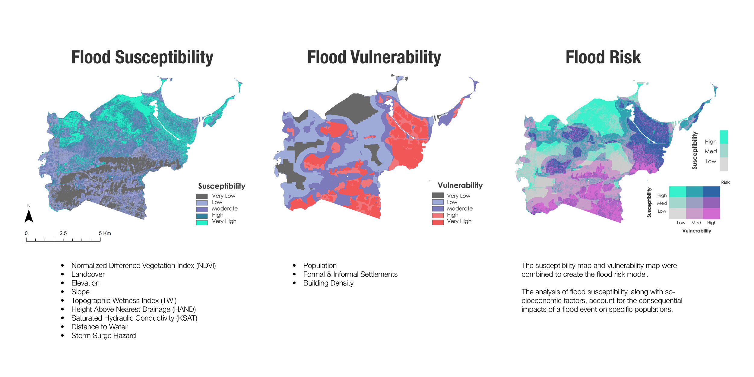
The project is part of the NASA DEVELOP program, in partnership with the Municipio Autonómo de Toa Baja, ResilientSEE, and the Massachusetts Institute of Technology (MIT) Urban Risk Lab. This project utilized datasets representing the topographic and demographic characteristics of Toa Baja, Puerto Rico to generate a spatial flood risk and susceptibility model. The outputs of this project serve to educate the public on flood risk and provide the Toa Baja Municipality with data-driven evidence to inform disaster mitigation efforts. Datasets were sourced in part from the National Oceanic and Atmospheric Administration (NOAA), the National Landcover Database (NLCD), and the European Space Agency’s(ESA) Sentinel-2 MSI. Additionally, Sentinel-1C-SAR data were utilized to visualize flood inundation from Hurricane Maria in September of 2017.
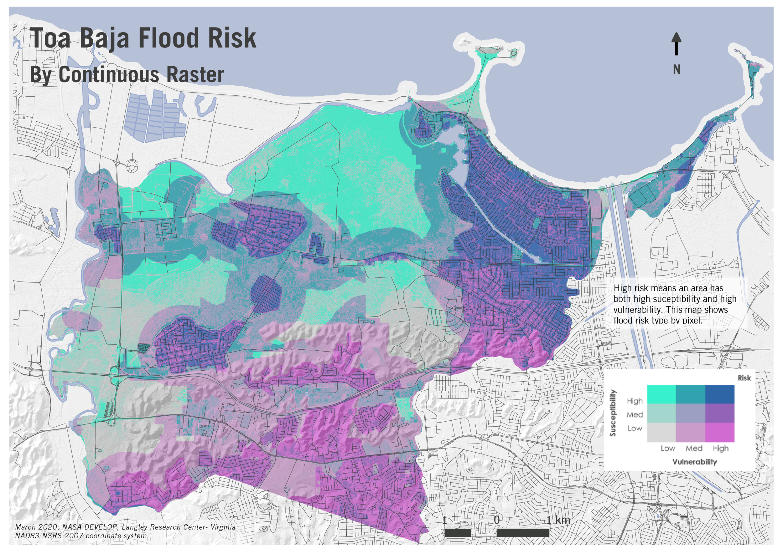
This project aims to use data to generate a flood susceptibility map and risk maps for Toa Baja. The ability to dynamically visualize flood events in the context of the area will allow city planners to prioritize regions in need of additional infrastructure to cope with the effects of tropical storms and will aide future development decisions.
The DEVELOP program is part of the Applied Sciences Program at NASA and conducts feasibility studies using NASA Earth observations to address community concerns. DEVELOP builds capacity of both partnering organizations and project participants.

To a Baja Flood Risk Map public platform to educate the public on localized flood risk
Project Objectives:
Provide Toa Baja with data-driven scientific evidence to inform disaster mitigation efforts and advocacy
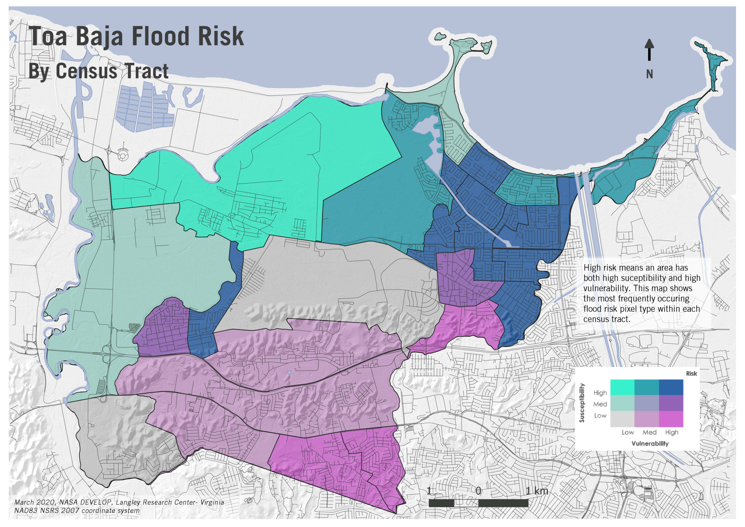
Provide Toa Baja with an GIS tool that used Earth observation products and paired flood susceptibility with human vulnerabilities to gauge relative flood risk
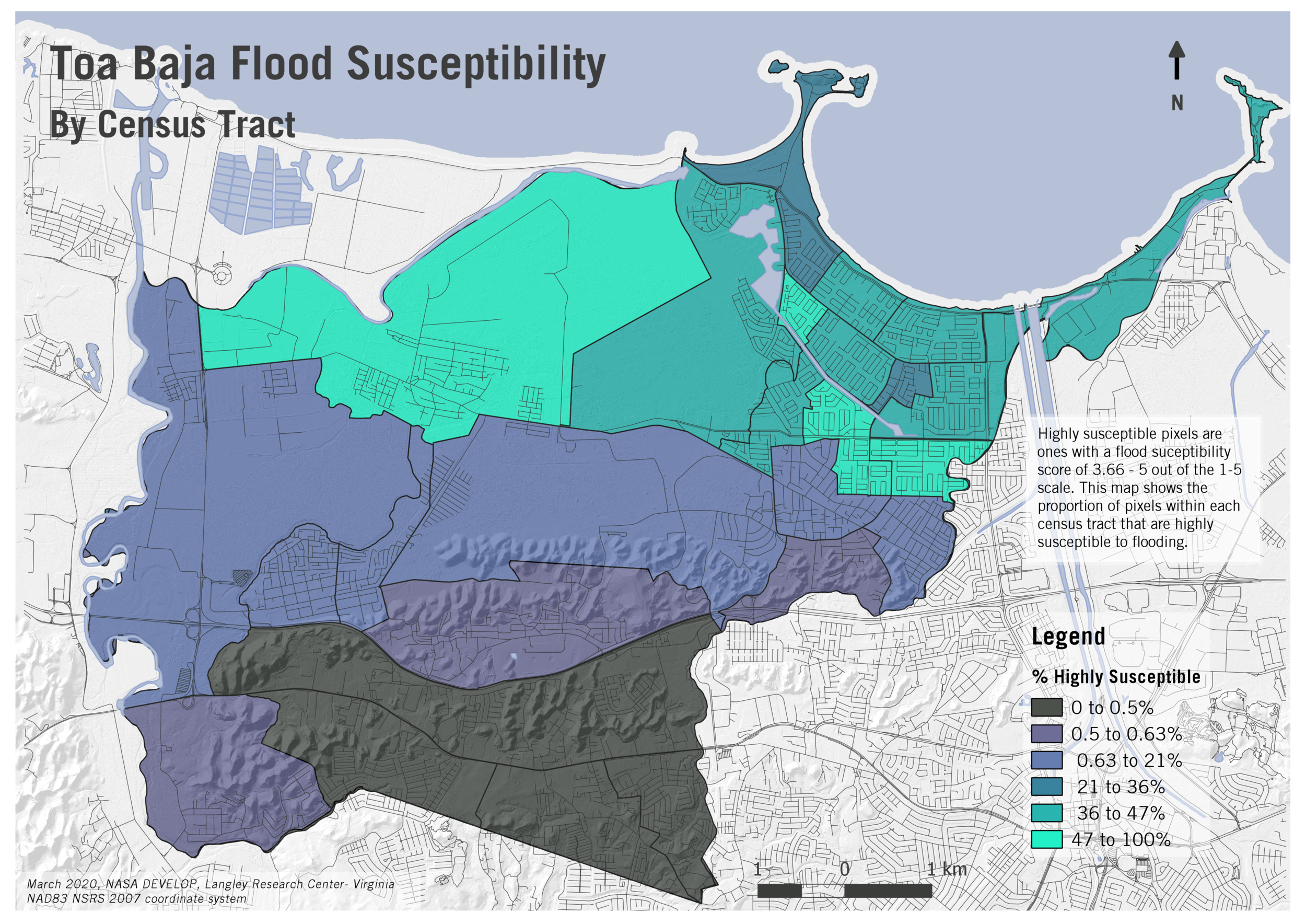
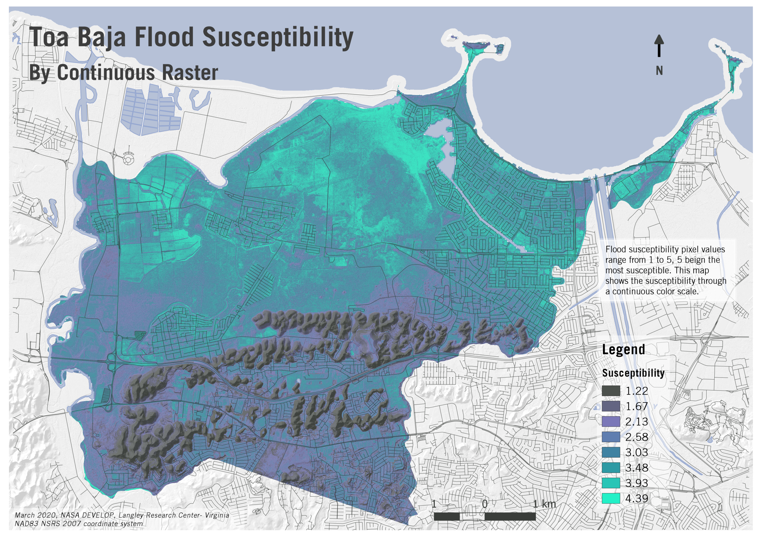
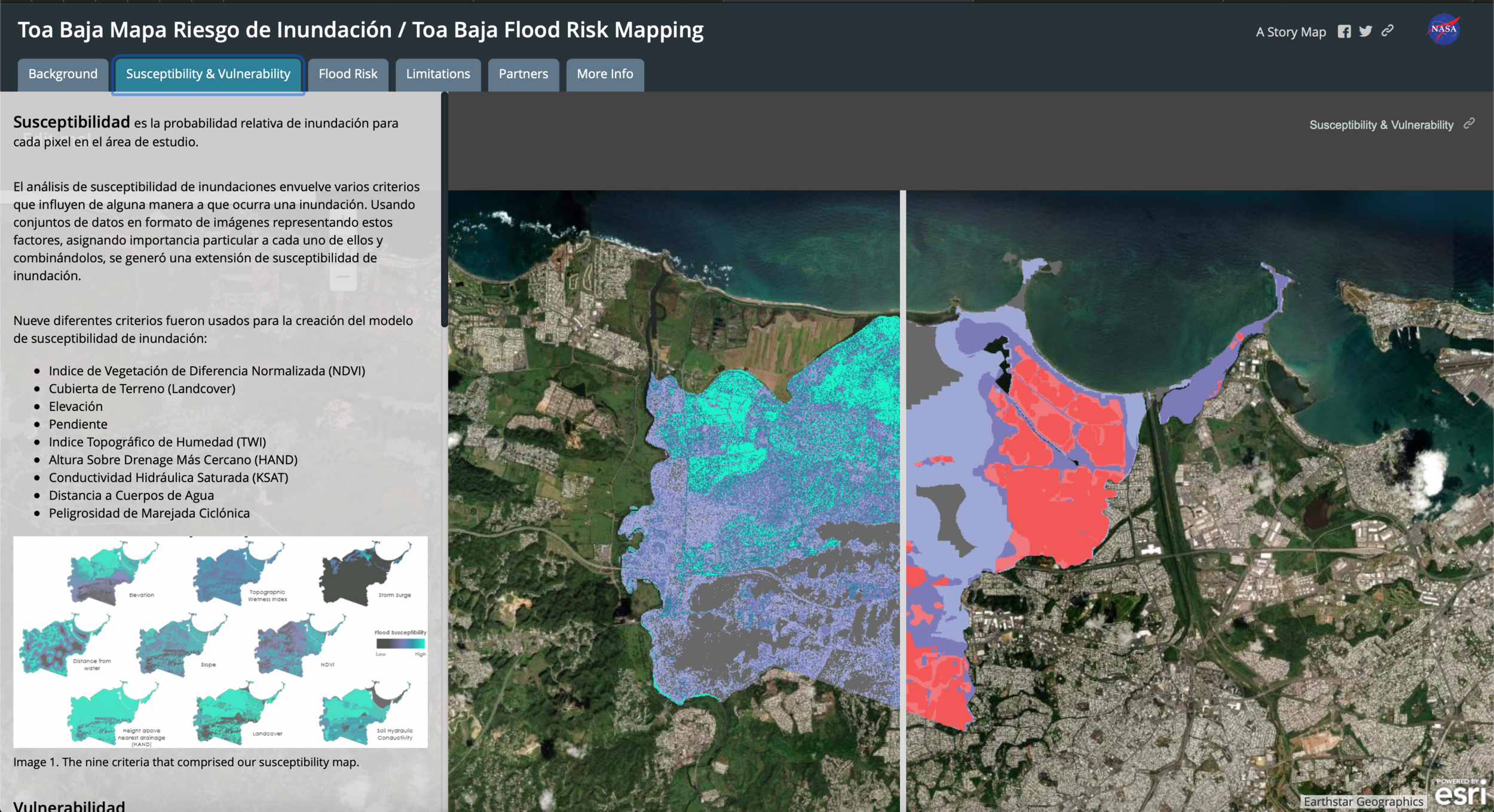
Utilize Earth observation products to model flood susceptibility
Compare the team’s measure of flood susceptibility with FEMA flood susceptibility maps
Provide a flood risk map to educate the public on localized flood risk and to overall improve public understanding of exposure to flood risk in Toa Baja
Awards:
The project was included in the entry for Resilient Planning at Multiple Scales Autonomous Municipality of Toa Baja, Puerto Rico and received two major awards:
Design Excellence Honor Award, Vision Category, National Organization of Minority Architects
Honorable Mention, ACADIA+Autodesk+NOMA COMPUTATIONAL DESIGN AWARD
Submitted In partnership with the Autonomous Municipality of Toa Baja (Puerto Rico), ResilientSEE, Perkins&Will, NASA Develop (Hampton, VA), Álvarez-Díaz & Villalón Architecture and Interiors (Puerto Rico), WSP (Boston, MA), Moffatt & Nichol (Florida) and SGH (Waltham, MA).
NASA DEVELOP National Program, Virginia-Langley: Project Team: Nara McCray (Project Lead); Scott Harrison; Wilfredo A. Garcia Lopez; Adriana S. Le Compte Santiago. Advisors & Mentors: Dr. Kenton Ross (NASA Langley Research Center); Dr. Venkataraman Lakshmi (University of Virginia).
MIT Urban Risk Lab: Larisa Ovalles Paulino, Miho Mazereeuw.
Municipio Autónomo de Toa Baja, Desiree Pearlman, Executive Assistant, Division of Economic Development and Tourism; Edgar Gomez, Community Outreach Director; Orlando Santaella, Municipality GIS Expert.
ResilientSEE: Yanel de Angel, Project Manager and Principal at Perkins & Will.